 Live Music Archive
 Librivox Free Audio
 Metropolitan Museum
 Cleveland Museum of Art
 Internet Arcade
 Console Living Room
 Books to Borrow
 Open Library
 TV News
 Understanding 9/11
tv Studio B With Shepard Smith FOXNEWSW October 29, 2012 12:00pm-1:00pm PDT
12:00 pm

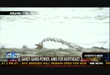
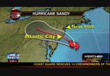
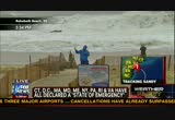
>>megyn: thanks for being with us on this special day. >>shepard: 3:00 on east coast and 50 million people across the east coast are facing what experts say could be the worst case scenario. they say this is it. a super storm on a path toward the region, the nation's busiest region. most populous, washington, baltimore, philadelphia, new york, long island, and into new england. officials declare emergency up-and-down that coast from the carolinas to maine. hurricane sandy is expected to make landfall earlier than we thought. that is important. we will get into the details. it is in south jersey right around atlantic city. the exact location is not that
12:01 pm
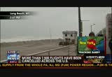
important. the whole region will get it. the flooding has begun in jersey and in new york. sandy is on a collision course with a winter storm from the west. and a blast of frigid air from the north. when the three systems meet, forecasters say that will create a once-in-a-lifetime weather phenomenon. >> do not underestimate this storm. these forecasts for the surge are really extraordinary. though are talking about surges that we have not seen before. there is nothing at all to be taken lightly. >> this is not a time to an show off. this is not a time to be stupid. this is a time to save yourself and your family. >>shepard: the governors of new york and jersey and the east coast grinding to a halt. 5,000 flights are canceled. mass transit in boston, philadelphia, washington, dc, and new york city at a standstill. the tunnels in and out of the manhattan, are shut down.
12:02 pm
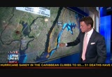
the train stations from new jersey which bring commuters close to a million a day into the city, flooded with 3' to 4' of water. we have a firsthand account that could mean long-term problems. schools, financial markets, businesses are closed all offer this region. new york city and surrounding areas bracing for what could be an 11' storm surge. >> fema personnel or working with state and local governments do make sure that food and water and emergency generation is available for the communities that will be hardest hit. >> on the east coast of our nation a lot of people are enduring some very difficult times. our hearts and our prayers go to them as we think about how tough it will be. >>shepard: the president and governor romney have canceled events because of the storm.
12:03 pm

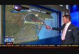
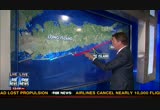
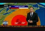
nasa shows hurricane sandy approaching the united states with tropical storm force winds extending almost 500 miles from the center. that is the biggest storm that ever hit the region since records have been kept. combined with high tide and a full noon and to other weather systems that the be part of this weather system and we are watching history in the making. this storm is going to come ashore sooner than we thought. it will come to sure more quickly than first forecast. with all of that if mind we have coverage with rick on the northern shore of new jersey and doug is in delaware, first, we will get to where we are and where it is going. and janice dean, what do we expect? >> a hurricane will make landfall across coastal new jersey, probably south and central jersey in the next several hours and expected between 5:00 and 6:00 p.m.
12:04 pm

eastern at 90 miles per hour hurricane. it will be a hurricane when it lands. there was a suggestion the last several days that it could combine with another system and become a super storm hybrid but now we are in agreement it will be a hurricane when it makes landfall. there will be storm surge with high wind in excess of 90 and 100 miles per hour in populated areas. we are dealing with a storm southeast of new york city and the effects of the storm when it lands in new jersey, anywhere north to the center the storm will get the worst rainfall, the worst wind, and the worst storm surge on top of high tide and we will see waves 20' to 30' on top of the storm surge and tim occur in two or three hours in central emergency and bring written and snow and hurricane force winds in some cases for six to nine to
12:05 pm

ten hours. >>shepard: the worst of it, as the case with every single hurricane ever is to the right-hand side of the storm so that means north jersey, new jersey, long island. >>reporter: worst case scenario for the most heavily populated corridor of the united states. because of way the storm is situated, the wind, counterclockwise wind will bring the surge into long island sound and the delaware bay and this is, this area of coast, winds in excess of 74 miles per hour for a very long duration and the storm surge is the number one killer when it lands with a hurricane. in some cases, 6' to 12' surge with 20' to 30' waves so we have an epic situation. >>shepard: and some blizzard
12:06 pm

warnings. >> we will see the potential of 2' to 3' of snow in the appalachian with bouys showing relentless wind for several hours. >>shepard: we have talked about worst case scenarios for years and there was in way for the forecasters to come up with a worst case scenario this bad. the storm normally comes up the coast, right in and though keep going straight but because of the high pressure center, has gone straight up and jogged right in. the effect of that is, rather than winds that are just sort of skirting now it will come in like a hammer. you can see the storm coming in right here, and the last jog, you can see when it comes back
12:07 pm
around, after it started headed in to new jersey it sped up so the forward motion of the storm, rather than 20 miles per hour it is now moving at 28 michigan and the last click as it speeds up, boom, right? that means the pounding of the worst of the winds will not last as long but because of the forward speed the pounding will be harder. think of trying to kick in your door, you kick it once and it doesn't break but if you kick it 100 times the door is going down. this is 100 time kicker. see how this is positioned here? this land mass? down here and then cross? all of that water is getting funneled in and it has nowhere to go so it goes into the river, in through here, and it floods this area. now the next map, these areas were evacuated in man the, now, whether everyone evacuated this is zone a, the east village over
12:08 pm
here, and this comes to avenue b along this side and this is the southern tip of manhattan where the world trade center is but further down, and, new jersey obviously is here. this is midtown manhattan and as under mandatory evacuation. this is already flooding. we are four to five hours away and the son tip of manhattan is flooded. it could come over the seawall and that would be worst case scenario. next map shows this is the larger area of evacuation, this is staten island, brooklyn, queens, the bronx and new york city, all of the yellow areas are evacuated. this is the beginning of doone road and let me show you the big concern. this is a barrier island, the hamptons which is out here, this is dune road, and this is fire island.
12:09 pm

this red for our purposes today means if they get what janice and everyone else is predicting, this is a 6' to 11' storm surge, this road which is a house on one side, house on the other side, bay here, ocean here, the ocean moves into the bay and washes it out. the dune should handle a category two. but this is a fall of water and the storm has been churning along like this and coming and coming and coming. it is in the middle of the bathtub, and like your hand is in the bathtub it is pushing the water, it is pushing across the ocean and it gets here suddenly there is a wall of water and the storm surge i have seen it dozens of times, the storm surge shows up, you have been watching for it hours and hours, you get a little water and suddenly there is a wall of water. they think they can go from this much water to way above here in a matter of minutes. that would in theory come over the dunes along fire island, and
12:10 pm
along dune road, back in the hamptons, flood over this and into this bay. next map, you can see where the previous map, thecy areas are on the long island sound, and the long tiled sound is right here. and this storm is movi this, right? so this water is going to come into the long island sound and push it to an area that is narrow which will create flooding here, so all of this is flooded, all of this, all of this, all of this, and most importantly here, where the fear is that the new york city subway system will flood. they have gotten all trains out of there but they worried now about the system, and the third rail which applied to the electricity. we are talking about salt water here. salt water in the subway station does not mix. local authorities have told new yorkers if the salt water gets in the subway system, we are in trouble. so new we will see what happens. we thing the storm is coming ashore right occurring fox report tonight. the storm now is taking dead aim
12:11 pm

for new jersey and we think atlantic city with the waves reaching the piers and could be about up to 15', giving record flooding like nothing that has been seen in recorded history. and now, near land dick city, choppy water and debris. one more thing, you measure storms in millibars of pressure, the lower the prior the stronger the storm. the lowest pressure in the last 60 years was 960 millibars, the lowest pressure ever recorded in the northeast united states from washington, dc all the way up north is 946 millibars. this storm is 940 millibars right now the strongest storm in recorded history in the
12:12 pm
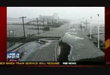
northeast united states. rick is on the beach of new jersey. rick, i am guessing it is getting to be a met. rick: a couple of hours ago we had an accurate wind reading of 57.6 miles per hour. it is above that now. between the sand and the wind and the rain, we are getting pelted and it is painful. low tide was two hours ago so the water is coming up a little bit. the streets of point pleasant are flooding. ocean avenue is still relatively dry which is comforting because that is our escape route. the ocean, though, is churning violently and has been since yesterday. this town, one of many along the new jersey shore that was evacuated, of course all the barrier items were evacuated, point pleasant issued mandatory
12:13 pm

evacuation order yesterday afternoon and put curfew in effect last night and tonight and no one is allowed in. if you are not here you cannot get in. in atlantic city we are told there are several feet of water on the roads and other towns south of atlantic city also underwater including the town of ava lone tens of thousands without power and a number of highways are closed including the garden state parkway from exit 123 down to cape may so virtually the entire southern half or more of the southern half of the garden state parkway is closed and other islands are shut down because of water on the road in both directions. the weather on the beach is getting worse bit hour.
12:14 pm

>>shepard: we expect the wall of water to come on the shore in the next three, four, five hours starting in new jersey and make its way to new york and out to long island and that is when there is trouble. continuing coverage right here. smoothest riding. it's got the most torque, the smoothest suspension, the best storage, class-leading comfort, and a revolutionary collection of versatile accessories. introducing the all-new, 60 horsepower ranger xp 900,
12:15 pm

a whole new class of hardest working, smoothest riding. get huge rebates on 2012's and low financing on all models during the polaris factory and loauthorized clearance.dels to bring you a low-priced medicare prescription drug plan. ♪ with a low national plan premium... ♪ ...and copays as low as one dollar... ♪ ...saving on your medicare prescriptions is easy. ♪ so you're free to focus on the things that really matter. call humana at 1-800-808-4003. or go twalmart.com forails.

12:17 pm

>>shepard: a few hours to landfall of the hurricane sandy which is expected to hit the jersey shore but affect almost the entire northeast united states. it is moving faster and the storm surge could be larger than first thought. if that is the case we are in a worst case scenario. and now, to a storm chaser traveling up-and-down new jersey right now near atlantic city now. how is it? >> the epic storm and we have been all down the jersey shore with a lot of water in land dick and ocean city with water inundating the area south to the
12:18 pm

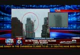
tip of cape may with high tide this morning we have water filled businesses and water rescues under way loan the coast. (inaudible). >> south of ocean city, probably the next hour and a half between cape may and ocean city, it will hit land. >>shepard: if you decided to stay in a home long the jersey shore on long island on the south shore or in connecticut on the bay on long island sound, the authorities will tell you, you made a bad decision but now there is no one to come get you. the authorities are wanting, hunker down, and why like to use that word but that is what they are suggest. breaking news now, file officials say a partial crane
12:19 pm

collapses happened in the center of new york city, 57th and 7th avenue. if you know new york this is just at the northern part of finals square. if you are in the middle of times square and you look up toward central park this is almost to central park, three or four blocks south of central park, a crane on top of a building under construction and they thought everyone would be fine and they tied it down but a crane is hanging off the building. and they worried it will fall. here is one thing about wind in the city the if you have 60 miles per hour wind on the concrete canyons which we expect, at the top of a 40 or 50 story building the winds will be much, much stronger. i will not give you a number but a gust could hit 90 or 100 miles per hour is not outside the realm of possibility.
12:20 pm
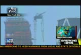
>> i look up and i saw the crane and it looked like it was about to fall on the beach. >> so, 57th is westbound and you get to 7th avenue which is, for our viewers looking south they would see times square and you have stuff raining on you. when you looked up and sought crane did it look like it had bent and broken and pieces had fallen off? what was your observation? >> no, it is hanging in the middle of the street and they did not close off the top so debris is falling. >> are they working to close down that area? the nypd is trying to get people out. >> a lot of cops had it brought to their attention and people are headed up. >> how long ago was that? >> it was half an hour ago.
12:21 pm

>> and did you see other pieces of debris fall? how big were they? was there damage? >> i saw one, a metal piece, and it fell in the middle of the road and there is a traffic light right under it so people were at the red light and did not know if they should move. >>shepard: thank you. this is one of the things which they have great concern because the winds will get stronger in new york city before they get weaker the we believe the level of wind we have now is the lowest level of wind we will have for at least the next 16 hours. there are big construction cranes on the lower end of manhattan at the world trade center and other construction cranes including at 14th street and 5th avenue a bunch of towering cranes all over the city. her to built to with stand wind but how much wind we will get? today was too much for this, and hopefully it will stay in the air and not crash. this is a lot of breaking news ahead as hurricane sandy works
12:22 pm

toward the shore, a monster, as the authorities put it, under worst case scenario, full moon, high tide, storm. @ ah.
12:23 pm

fire bad! just have to fire roast these tomatoes. this is going to give you a head start on your dinner. that seems easier [ female announcer ] new progresso recipe starters. five delicious cooking sauces you combine with fresh ingredients to make amazing home-cooked meals.

12:25 pm

>>shepard: 25 minutes after the hour. the storm is scheduled to hit along the jersey shore. this is point pleasant, new jersey. a weekend get appear type place. sometimes family move down for the summer and whoever the working person is joins on the weekend, an area they are very worried about. and our reporter is in pleasant beach, in new jersey. it will come, now, we think, a couple of hours before high tide because it is coming in quickly. >>reporter: high tide is 7:16
12:26 pm

along beach and when we had high tide this only we had a major surge. you can see this behind me. it is starting to surge right now. we have flooding downtown. the headline story is going to be what the surge does. i don't know how much more the wind will blow but i am impressed with this, it has been unrelenting. you usually have breaks with hurricane. but it is increasing in intensity. the surge is starting. four hours away from the high tide. if we get it in sooner, it will be better. >>shepard: the thing is, it will come in because the stock market has sped up so much but -- that would be terrific, coming in at 5:30 like we hope but we are talking about a storm subject that is higher than you. >>reporter: this is the kind of storm we don't know what we are dealing with.
12:27 pm

we have a category one storm plus whatever else is out there in the atmosphere. i don't know how bad it will be. we had surge up to the boardwalk. you have probably been on the boardwalk here with surge up to the boardwalk this morning at high tide. the question is, how high does it get at high tide this evening in -- and beyond? >>shepard: are the winds sustained? >> i have been impressed with the intensity of the storm. you usually get ribbons of bad stuff, and bands of rain and bands of wind. this has been constant and i think it is because of the combination of systems. that is what impressed me. there has been no back off. >>shepard: thank you, jeff, from the point pleasant, new jersey, get away vacation on the
12:28 pm

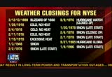
shore. >> and now north of times square, 57th and seventh avenue, a 65-story luxury building, the streets are now cleared and emergency workers have rushed to clear all of them as a precaution. i don't know how they come to this thinking but i understand that they think the crane will not collapse. even at the height of the storm. the center of the storm will be in where around 80 or 100 miles south of the city but the stock market ishat they are worried about hurricane force gusts certainly 65 stories up and the hope is that the crane will stay in the air. official announced the stock exchange, the new york stock exchange, will stay closed for a second day tomorrow. the last day weather caused that the man in the white house was grover cleveland. gerri willis coming up with what that means for 401(k)s and millions could see the effects
12:29 pm

that matter where it lands and it is suggested that 60 million people are in the path of this storm. now why it is a once-in-a-lifetime event.


12:33 pm
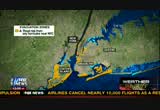
stopped. a bridge, also, will close, a bridge that connects west chester county with new york, and the george washington bridge and other bridges may have to close. the higher the wind, the more chances of that, the largest city in america will come to a complete grinding halt. the delaware governor has ordered a mandatory evacuation for many coastal communities in delaware. the order covers 50,000 residents. the governor also issued a partial declaration of emergency, the officials at dover air force base relocated we aircraft, and doug went there in anticipation. what is it like on the ground? >> there are two major developments in the last hour. route 1 which is the major coastal artery between where i now stand and rehobeth that cities dewey and bethany and
12:34 pm

fenwick island has been shut down because of flooding. the chesapeake bay bridge, a huge bridge that connects delmarva with washington, baltimore and philadelphia, has been shut down because of high wind. we do not know how long that will last but that is the only way to get back to the three major cities from the delmarva peninsula without going all the way down to the tunnel in for -- norfolk. now, the wind coming from the
12:35 pm
northwest and the effect has been to flat were the seas. rather than the roiling water we had the waves are more regular than the we big breakers that curl over and splash with tremendous force. high tide is at 8:10. whether the shift in the wind will flatten the surge, we do not know. if that is, that is a blessing. if not we could be in for another rough note with the erosion on to the boardwalk. we watching closely, high tide is at 8:10. it will be coming up on the fox report and we will see how we are doing. >>shepard: now to fox 5 at new york, and there are some changes in the track. what is the weather? >> you can see the winds at the
12:36 pm
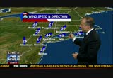
airports at 40 to 45 sustained wind, and new gusts are up to 64 which are the strongest we have seen, and gusting to 50 in newark but they can do damage. certainly, it and no easy task to be able to drive the car cross bridges in this regard and keeping both hands on the steering wheel. the driving rain against your body with a 60-miles-per-hour gust is nothing of pleasure. here is the storm at 3:00, the old advisory that will need to be updated because at 8:00 p.m. it was offshore but that is not going to be the case. this red is the wind profile greater than 75 miles per hour so it looks like the gusts of hurricane force are greater and may not make it town the city but the red area, the lighter red you see are gusts in excess
12:37 pm
of 50 miles per hour and we are covered by that and look at this large area of orange, they are the tropical storm force winds and they go outward 435 miles from the center so we will be affected by those and the tide tomorrow, it will be windy and sandy will get it to slow down and only gradually weaken. >>shepard: but everyone is putting it together now, the storm has sped up so much that it now appears it will not come in at the worst time which is high tide along the jersey shore and the long island, the south shore of long island. in connecticut it will come in a couple of hours early so the storm will come in while the tide is lower so it will be a lower surge so we may only get a maximum of 9' surge. it could save hundreds of homes. hundreds. especially along the south shore of long island, possibly save a town or two or a dune or two, the difference in 2' of storm
12:38 pm

surge is life-and-death. and now, inform chaser in south jersey, a storm chaser with water ahead. >> i have quite a bit of water. tell us about your situation. >> i have been coming up i-45 trying to get to atlantic city and maybe cape may and i-95 i don't know what you know but the bridge across chesapeake bay is down. i was one of the last few cars going across an hour ago. the interstates are not existent, there are no cars. you have an occasional car, and i have seen several wrecks because the high winds are blowing the cars off. the cars are hydroplaning. >>shepard: it appears more people have stayed in south jersey than the governor hoped. >> i would say so. it looks, this is no traffic out which is nice to see that people are not getting out and the win
12:39 pm

winds are not real bad. they have shifted from the northwest. at times there could be 35 or 40-miles-per-hour gusts. >>shepard: in the way of water, you have covered the areas before, have you ever seen nothing like this? >>guest: nothing this far north the i have chased hurricanes for 25 or 30 years and this is just so long lasting, isaac was a slow-moving storm but this will be a long duration because of the size of this thing. >>shepard: appreciate your input. the worst of this is not yet here. 9 worst of it is a ways away and the major stock exchanges closed in the first unplanned shut down since the attacks of 9/11, and
12:40 pm

the major bond and stock markets will remain closed tomorrow the first time since 1888 weather had force add shut down of the new york stock exchange for two consecutive days. let's talk about the closure and why they hesitate to close it. i remember major giuliani got the stock market opened a day early by pulling some chains and people say that could have saved that market from collapse. gear it is critical to be able to trade in the stocks and be able to bay, to sell, that is what investors rely, you have access to the stocks and that makes the stock market work. closing down for a day is rare. the last time was 1985, hurricane gloria. now they are saying they will re-open on wednesday. commodities were open because it
12:41 pm
is done by electronics and crude oil was down, and not a volume on trading. a lot of people not on the island fed. the market is closed and transportation is closed down. quickly, this is not the markets but something different. chase and city are waving a.t.m. fees, late fees, overdraft charges for customers in this area, new york, new jersey, connecticut, during the storm. >>shepard: and another thing before we get away, there is a concern that this salt water will get into the subway system and the area where all the electrical grid is which is not above ground but below ground and it will get in there and cause real problems if they lost electricity for a number of days there would be trouble. >>gerri: yes. and it is all rock there. there is not a lot of room to maneuver. it could be trouble for the markets and a lot of trouble for people commuting into the city. we have been waiting for the
12:42 pm

jobs report on friday and discussion whether that could be delayed. the labor department spokesman said it will be not delayed and they are working to ensure the timely release of data and it is said to come in at 7.9 percent, higher. >>shepard: and now to the midtown manhattan above times square where the crane is dangling where a red alert from the reuters news agency, the new york city officials are ordering the evacuation of upper floors of buildings in this area around the crane. i suppose the concern is a bad wind gust could take and crash it into another building. the building is 65 stories tall and that crane is now dangling a total of what would be 8 to 10 stories and i suppose they are afraid if it falls it could crash into the side of a
12:43 pm

building. what will happen on long island where millions commute into the city or live out there and work out there? it is america's first suburb. their trains are shut down. their transportation systems are shut down. now the fear is that storm surge will crash into the south shore of long island and cause damage like no one ever thought of.


12:46 pm

>>shepard: a change in speed but not a change in course. hurricane sandy hit the jersey shore in a couple of hours and towns along new york's long island will be affectedth shoreh tens of thousands without power, and more than a foot water is reported on some streets along the south shore especially at mid-island. and several towns under mandatory evacuation orders and the national weather service reports the storm surge could be
12:47 pm

6' to 11 feet above the inflated full moon tide compared with the storm surge you have serious flooding. and jonathan hunt is live from long beach on long island. i have been watching shots. it doesn't look good. >>jonathan: it doesn't look good. you can see the waves are already getting up to something like 12' to 15'. most importantly they are getting closer and closer to the boardwalk we are standing on. when we get that surge, 11' with the waves of 12- to 15-', the sand berm will not stand a chance. they can something similar last year and it was swept away. you could recognize from 14 months ago from the same spot the life toward station was moved by orders, some 100' and this time it will possibly be
12:48 pm
disindustried altogether. across long island, it is a similar story. we have reports of flooding, bad flooding, further to the east along long island, the area that many know as the hamptons. something like 50,000 people have been cut off from power according to the long island power authority and it and likely to get worse. parts of the boardwalk are solid under and this is not. a lot of the lifeguard material is under here so you have a situation when the water comes in, it will sweep 78 through here and out there the homes of long beach and there is every chance that many of those homes will be flooded. these beach towns are full of stuff and stubborn characters and a few of them are standing around on the boardwalk. i spoke to the city manager of long beach who said please, please, please, everyone, get out. >> this year it is the time to
12:49 pm

go. we see that right now folks are taking a second look at the storm and the flooding has been serious already although the storm has not arrived. folks are listening now and starting to realize, guess what, maybe i ought to go. we want you to know, yes, now is the time. >>jonathan: now is the time to get out. the window to get off of the barrier island is shrinking by the minute. high tide begins at 7:00 p.m. in three hours, about, and the most dangerous time are the hours from 7:00 to 11:00 and after that the surge will come in. after that, it is anybody's guess what will be left of this boardwalk, what sort of damage will be done to the many homes on long beach and across the entire length of long island. >>shepard: johnathon hunt, thank you. and now the crane situation in midtown manhattan. on the last sired, that is what
12:50 pm
it used to look like and on the right side of the screen in the square, that is what it looks like now, it is hanging. all of the streets below are closed and the fire department and nypd was there and the streets are clear and occupants of floors around there have been evacuated to the lower floors and the treaty between 6th and 7th avenue and the cross streets are evacuated. the weather loop indicates this is coming ashore early. what time there is no way to know. but the storm surge is on the way. the thinking now is that the storm surge will happen during daylight hours. we are beyond hopeful that the speed up of this storm may be the boast news of the day. high tide, depending on the shoreline, between 7:00 p.m. and 8:30 p.m. if the storm gets in by 5:00
12:51 pm

p.m. this region may have dodged a bullet. [ male announcer ] this is sheldo whose long day setting up the news starts with arthritis pain and a choice. take tylenol or take aleve, the #1 recommended pain reliever by orthopedic doctors. just two aleve can keep pain away all day. back to the news. i just finished a bowl of your new light chicken pot pie soup and it's so rich and creamy... is it really 100 calories? let me put you on webcan... ...lean roasted chicken... and a creamy broth mmm i can still see you. [ male announcer ] progresso. you gotta taste this soup.


12:54 pm

>>shepard: coverage of hurricane sandy and the destruction across the northeast united states. we believe the storm is coming in earlier as i mentioned. that doesn't mean the storm surge will not be bad. it will not be as bad as it would be at high tide. the thinking is wide-spread flooding and potential for wide-spread damage across hundreds of miles. coney island in brooklyn is along the water and a councilman is with us. what do you see, councilman? >> well, it is getting worse. the timing of the surge is coming in and the waves are
12:55 pm

getting taller. i have never seen it like this before. the cops are trying or getting much more bossy getting people off the beach telling them to go back home and to go inside. it is amazing how many want to come out and see the ocean. i wish they would stay in. parts of coney island are getting flooded. once high tide comes in at around 8:00 it could be devastating for coney island. >>shepard: councilman, i understand so many people have not heeded the advice of authorities to get out. there are mandatory evacuations but no penalties if you don't evacuation wait. >>guest: that is not really true because the police department on one of their flyers they said that any person knowingly violating the order could be charged with a class d misdemeanor and many residents saw there and they got scared
12:56 pm
and we were explaining to them, don't worry, leave, and we will protect you if something happens. >>shepard: councilman, thank you. our courage continues right after this. e announcer ] the rhythm of life. [ whistle blowing ] where do you hear that beat? campbell's healthy request soup lets you hear it... in your heart. [ basketball bouncing ] heart healthy. great taste. mmm... [ male announcer ] sounds good. it's amazing what soup can do. or annuity over 10 or even 20 years? call imperial structured settlements. the experts at imperial can convert your long-term payout into a lump sum of cash today.

12:58 pm

and i'm here to tell homeowners that are 62 and older about a great way to live a better retirement. it's called a reverse mortgage. [ male announcer ] call right now to receive your free dvd and booklet with no obligation. it answers questions like how a reverse mortgage works, how much you qualify for, the ways to receive your money, and more. plus, when you call now, you'll get this magnifier with l.e.d. light absolutely free. when you call the experts at one reverse mortgage today, you'll learn the benefits of a government-insured reverse mortgage. it will eliminate your monthly mortgage payments and give you tax-free cash from the equity in your home. and here's the best part -- you still own your home. take control of your retirement today.
12:59 pm

♪ ♪ >>shepard: just in, federal government offices in washington, dc and surrounding areas will be closed to the public tomorrow but we have word that emergency workers are expected to report if duty as normal. the crane situation in midtown manhattan is continuing to be precarious. you can see the crane is still dangling 65' in the air. authorities closed the streets off. and there is the situation with the storm which we now believe will come on to shore in the next hour or hour and a half. that is the hope if that is the case it will come in ahead of the projection and ahead of high tide which could be a save your. in the last 60 years in this region we have never had a storm this strong. the last ti
291 Views


Uploaded by TV Archive on
